
In previous articles we discussed what to look for when shopping for the perfect chartplotter.
- Does Chartplotter screen SIZE really Matter
- Chartplotter Maps – Pick the RIGHT Cartography
- Do you need a Touch Screen Chartplotter?
It is now time to delve into what each of the manufacturers is offering and we are going to start (in no particular order) with the Garmin Chartplotter.
Garmin is a major player in the marine chartplotter business and an even bigger player in the aviation business. The technology and advancements that they have developed for their aviation navigation has naturally flowed to the company’s marine units and a robust, reliable and technologically advanced marine chartplotter series has been the end result.
All their plotters can be viewed at www.Garmin.com
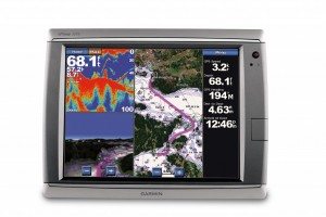
With their Garmin chartplotter ranging from the small but sophisticated chartplotter such as the Garmin 441S with its four-inch display and built-in sounder to the sophisticated, integrated GPSMAP 7215 15-inch diagonal touch screen multifunction display Garmin has something to offer for anyone looking for a chartplotter. Screen sizes are available in 4, 5, 5.2, 7, 8.4, 10.4, 12.1 and 15 inches (measured diagonally).
The Garmin Chartplotter with the G2 Vision card is one of the few chartplotter manufacturers that offer auto routing capability
All sizes of the Garmin chartplotters offer their G2 coastal cartography for the US and Canada pre-loaded. This software includes channel markers, spot soundings, depth contour lines as well as tide information and data on marinas and waterside facilities. This software is one of the best “standard” cartography to come pre-loaded on a chartplotter and is detailed enough to make it comfortable for most to use while navigating (of course not relying solely on an electronic chart is always a wise decision).
Go the “Safe” Route with Garmin’s G2 Vision
Garmin’s G2 Vision software that can be added to ANY of their current fixed-mount Garmin chartplotter has additional cartography and data. With the G2 Vision card inserted in the SD card slot the chartplotter enters a whole new level of detail and functions.
In fact, Garmin with the G2 Vision card is one of the few chartplotter manufacturers that offer auto routing capability. Once you set the chartplotter up with your vessel’s draft and overhead height, the chartplotter becomes capable of creating a “safe” route for you to travel, keeping you away from obstructions and creating a safe route to your destination. The screen (while in mariner’s eye view) will even color code the water for you with blue being safe, yellow getting shallow, orange where you are kicking up bottom and red hard aground. The chartplotter creates a clear and easy to follow purple pathway for you along your route.
Other features of the G2 Vision software include aerial photographs, satellite image overlays and 3D bathometric charts that render 3D depictions of the area’s bottom structure. Garmin offers all these features and does so in its legendary simple and easy to understand interface.

Garmin’s 2013 Lineup
Brand new to Garmin’s lineup for 2013 is a series of five- and seven-inch chartplotters it bills as “the power of simple” due to their ease of use.
These new stand-alone chartplotters are sporting a new 10Hz GPS engine that updates itself 10 times per second (much faster than current sensors).
They also have Garmin’s new HD-ID Sonar capability for extremely detailed sonar images.
The plotters are the first in Garmin’s line to have wireless connectivity, allowing interfacing with smart phones and tablets.
Other new features that will be offered in these new Garmin chartplotters include pinch to zoom touch screen capability (on their 7-inch models) as well as sonar recording and multiple mounting options.
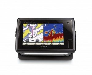
These new models are offered in a premium line as the 7-inch GPSMAP 741xs and the 5-inch GPSMAP 547xs with built-in high end HD-ID sonar and CHIRP sounder capability along with an improved processor.
They also feature radar support, video input and NMEA 2000 connectivity.
Garmin also offers two echoMAP models. The-7 inch echoMAP 70s and the 5-inch echoMAP 50s offer the improved GPS sensor along with HD-ID target tracking and the same sounder technology as their existing echo fishfinders. All of these new models are available in a chartplotter-only version.
Whether you go for one of Garmin’s stand alone chartplotters or one of its integrated modular systems you are sure to have a machine that is technologically advanced yet reliable and one of simplest user interfaces available.

