
Humminbird has often been known as a premiere fishfinder for freshwater fishermen and although this is still true the company now has a line of chartplotters that are being seen more and more on saltwater fishing boats. These sophisticated chartplotters have features any fishermen would want, combined with some unique capabilities that separate them from their competition.
There is no doubt that every one of Humminbird’s chartplotters is directed towards fishermen. With a line of plotters that range from a 3.5” display in their 300 series machines to upwards in their 500 series (5” display), 700 series (5” display), 800 series (7” display), 900 series (8” display) and their top of the line 1100 series sporting a 10.4” display, there is certain to be a model that would fit the need of any fisherman plying the coast or lake.
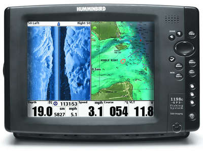
With several models in each line you can go from a basic chartplotter with Humminbird’s proprietary UniMap™ cartography that covers the continental United States coastline, major inland lakes and rivers with 30 meters per pixel resolution, all the way up to the sophisticated 800, 900 and 1100 series chartplotters with multiple charting options. Those options include LakeMaster charts, Navionics Platinum, Navionics Gold, Hot Maps and Humminbird Contour XD cartography.
LakeMaster cartography can be added to all of Humminbird’s chartplotters that accept chart chips but the charts have capabilities that are unique to Humminbird’s top lines of chartplotters. For example, once loaded a user can adjust the contour lines to reflect high or low lake water reflecting an accurate water’s edge and adjusted depth contours, making navigating safer and fish finding more accurate (this feature is particularly useful in lakes and waterways that are exceptionally low due to drought).
Users can also select a depth zone to show on the charts if fish are holding to a certain depth range. These features allow for instant color-coding and easy interpretation of depth contours.
Navionics Platinum cartography adds all the same features found with the charts in other machines such as 3d bathometric, satellite imagery, aerial photos, etc. Humminbird Contour XD is another of Humminbird’s proprietary charting that is preloaded on 1100, 900, 800 and some 700 series combo chartplotters. These are detailed contour charts of over 3,000 US lakes and can include contours not found on other charts.
All of the cartography options available in Humminbird’s upper echelon chartplotters make them an excellent choice particularly if you are plying the waters of lakes and rivers, but these combo units really shine when used in conjunction with their depthsounders. The chartplotters can be purchased with different combinations of bottom sounders. You can go with Down Imaging® (a high detail, high definition bottom reading similar to Humminbird’s Side Imaging® but looking straight down). Side Imaging is also available, giving the user 180-degree coverage with side imaging equivalent to “throwing a 480 foot net.” A user can even add an optional retractable transducer element that allows for a 360-degree view around the boat. If you see something interesting on the sounder just mark it and it will show as a waypoint on the chartplotter. Not only that but if its saved as a waypoint in your stored database a screen shot is saved with the coordinates so you have a record of what was below and around the boat when the waypoint was marked.
Bill Carson of Humminbird points out that another unique capability of these chartplotters is that of controlling the trolling motor. If the chartplotter has LakeMaster cartography loaded and an iPilot equipped trolling motor the motor can be directed to follow a contour line or run at a certain depth according the cartography on the plotter. The controller can even direct the motor to run at a certain offset from the depth contour to help present baits at the right depth. “I use it myself and it’s great,” he says.
With all these tools at your disposal not only lake and river fishermen should look at Humminbird’s offerings but also those fishing inshore and near shore. With all of the technology employed by Humminbird’s top of the line machines you can not only find your way but you can also find and track your dinner.

